Wensum Way
This a completely signposted well used route running from Gressenhall and finishing in Lenwade at the Marriots Way carpark on Porters road. The route is just under 13 miles.
The route is on a combination of track, road and meadows so can be uneven and slippery in places. There is a small diversion about 3 miles from the start that follows the edge of a field as a pedestrian bridge across railway tracks has been removed. Th road sections of the route are on quieter roads but extra care will be needed while running on these sections.
There are parts of the path that can become very wet and due to animal grazing on these parts they can become uneven with some deep holes to avoid. Just outside Lenwade there is a length of boardwalk I would encourage runners to walk this section if its wet and it can be lethal.
Runners also need to aware of any animals grazing in the fields and that walking is very often the safest thing to do when passing through or past livestock.
Route:
(click the image to download full map and turn by turn instructions)

Holt – 4 Mile
We exit the carpark heading onto the heath then follow the right hand path to a opening which crosses Holgate Hill. Follow the track all the way to the crossing. Cross the tracks with care and follow the path that is directly ahead of you. Following this path you come to the first camping field on Kelling Heath here we take a right turn and follow this path all the way until it turns in to Warren Road. At the end of Warren Road turn left onto Bridge Road eventually crossing Cromer Road to join Selbrigg Road. Stay on Selbrigg Road until you come to a right hand turn to Selbrigg ponds and Hempstead. Opposite this turning there is a footpath sign that enters the woods, follow this path and it will take you back to the Cromer Road.
Cross Cromer Road with great care then follow the footpath down the edge of some houses. When you get to the end and go through a barrier turn left and continue to follow the back fences of the houses. The path then turns right and goes past a farmhouse and some horse fields. Once you have past the last horse field turn left and follow the path taking you back to the track that led you to Warren road. Turn right then left and follow the track all the way back to the crossing. Once over the crossing continue on the path cross Holgate Hill and once on the Heath turn left and return to the car park.
4 Mile Route:
(click the image to download full map and turn by turn instructions)

Holt – 6 Mile
The run exits the carpark to cross the heath and then follows a footpath down a hill to then reach the Street in Kelling just beside The Pheasant Hotel. We cross the road onto a footpath that runs along the inside of the hedge parallel with the road towards Kelling School. The path exits the field and we turn right to follow the path down towards the shingle bank. Once we reach the shingle bank we turn right and follow this route until we reach the carpark at Weybourne beach.
We come of the shingle and run through the carpark onto Beach Lane which then rejoins the Street. Crossing the road opposite the Ship Inn we then turn right onto Church Street then follow this before taking a left onto Station Road. Stay on Station Road all the way to Weybourne Station. Go straight up Sandy Hill Lane once at the top turn right into Kelling Heath Holiday Park.
Follow the main road to go past the reception area eventually coming to a camping field. We then join a track that takes us all the way back to the track crossing. Cross with care and follow the path until you come to Holgate Hill. Cross this road and you are now back on the heath near the carpark. Turn left and you will arrive where we started.
6 Mile Route:
(click the image to download full map and turn by turn instructions)

Glandford – 4 Mile
The route is mainly off road. From the carpark we follow the track that heads up the hill towards a wood. Before the cattle grid we follow the track round to the right and run up a small hill.
Once at the top we follow the track round a right hand corner and continue to climb and pass through a wood before the path then comes to a left hand corner. Following the track we go down the hill to meet Dragway. We cross this road onto another track that goes up through a wood. We follow this until it turns left down a hill and meets Blakeney Road.
We cross Blakeney road going through a kissing gate into the field. We head left along the path towards another pedestrian gate in the left hand corner of the field. Passing through the gate we follow the path right towards the Bayfield café. When we come to the carpark near the café at the end of the road we run through it. When we reach the gate we turn right and climb a large hill. At the top we follow the track that takes us all the way to Walls Lane. We turn left and follow the road all the way back down the hill to the Ford. We cross the ford on the footbridge and then go up past the shell museum and the church. Once at the junction we cross the road and arrive back to the carpark.
4 Mile Route:
(click the image to download full map and turn by turn instructions)

Glandford – 6 Mile
The 6 mile route will exit the carpark crossing Blakeney road and then running towards Hurdle lane past the church. We cross the river Glaven on the footbridge. Running up Hurdle lane for about ½ a mile , as the road turns right we continue straight onto a footpath that takes us along the edge of a wood. We continue on the path until we come to Cley road. Crossing Cley road we then follow Bard road until we reach a cross roads. Turning left we follow Wood lane all the way to the junction that meets Bridgefoot lane.
This road can get busy so cross with care. Cross into a field that has a footpath running down the left hand side. We pass through many fields taking us downhill towards the coast. Keep to the footpath until we reach the car park at the bottom near the coast road. From here we turn left and then cross into a small carpark that has a footpath going left that takes you back towards Cley.
Just past the Cley and Salthouse marsh café and information center cross the coast road again onto Old Womans Lane. This small road takes you back towards Glandford bringing you out on Holt road. Turn left and follow the road for a short while up hill until there is a footpath sign on the right leading into some trees near a house. Continue on this path to reach Bridgefoot lane, turn right and run down the hill. Be careful of traffic this road can be busy. At the bottom of the hill turn left into Glandford road this will take you all the way back to Glandford river crossing. Cross the footbridge returning to the carpark up the same road as we started on.
6 Mile Route:
(click the image to download full map and turn by turn instructions)

Binham – 4 Mile
The route is a mixture of on and off road. We exit the pub carpark onto the Hindringham Road, we turn left onto Warham Road and follow the footpath until we come to the start of the priory wall. We cross the road here following a footpath that takes us through the Butlands, (a group of houses and cattle shed that are used for parking). We then pass throught some concrete post onto a grass pathway. Continue on this path and you eventually meet Walsingham road. Turn right and run a around 70 meters until you come to a grass track on your right. Take this path follow it for about 1mile you will cross a field and meet the Wighton road at the end of it.
We run left along the Wighton road until we pass a cream house on the left, on the opposite side of the road to the house there is a dirt farm track. This is a footpath, follow it all the way to the end arriving at Warham Road. You will pass a house and farm buildings on your left while running down this track.
Please be aware of the busy road. Cross over with caution to a gate that is the start of a path across a meadow to a wooden bridge over the steam. ( There may be cows or horses in the field please walk). Once over the bridge follow the hedge line to the right eventually arriving at a stile and a 5 bar gate.
Climb over the stile and continue on this track for about three quarters of a mile, up a hill and past a Sugar beet pad until you meet the Stiffkey road. On meeting the road you turn right and follow the road for just over a mile down into Binham. Near the bottom of the hill just past the speed limit signs you will come to a hose on your left. Turn right here on to a by road. Follow it and when you reach where a fork to go left or right, turn left and use the footbridge to cross the stream. Continue up the hill until you reach the cowsheds, turn left onto the footpath and follow this path along the side of the road passing The Priory on your left and eventually arriving back at the front of the pub.
4 Mile Route:
(click the image to download full map and turn by turn instructions)

Binham – 6 Mile
On the 8th September 2024 the following social run is taking place in and around Binham. We will be meeting at The Chequers pub to start at 10.30 am.
The route is a mixture of on and off road. We exit the pub carpark onto the Hindringham Road, we turn left onto Warham Road and follow the footpath until we come to the start of the priory wall. We cross the road here following a footpath that takes us through the Butlands, (a group of houses and cattle shed that are used for parking). We then pass throught some concrete post onto a grass pathway. Continue on this path and you eventually meet Walsingham road. Turn right and run a around 70 meters until you come to a grass track on your right. Take this path follow it for about 1mile you will cross a field and meet the Wighton road at the end of it.
We run left along the Wighton road passing a cream house on the left then passing through houses and barns on both the left and right hand side of t he road. We then come to a turning on the right onto long lane taking us past a pig farm. Follow the road for about a mile until we meet the Warham Road. Cross the road with caution onto Wighton road and follow this up hill to Choseley then down the other side meeting the Stiffkey road. Turn right and run up the hill until you get to the top and come to a right hand turning to Binham. Turn right and follow this road for about a mile and a half down towards Binham. Near the bottom of the hill just past the speed limit signs you will come to a hose on your left. Turn right here on to a by road. Follow it and when you reach where a fork to go left or right, turn left and use the footbridge to cross the stream. Continue up the hill until you reach the cowsheds, turn left onto the footpath and follow this path along the side of the road passing The Priory on your left and eventually arriving back at the front of the pub.
6 Mile Route:
(click the image to download full map and turn by turn instructions)

Blakeney – 4.5 Mile
4.5 Mile Route:
(click the image to download full map and turn by turn instructions)

Burnham Market – 4 Mile and 6 Mile
4 Mile Route:
(click the image to download full map and turn by turn instructions)
6 Mile Route:
(click the image to download full map and turn by turn instructions)

Wells – 4 mile and 6 mile
Description:
This route starts on the Buttlands in Wells, it then follows a footpath towards Holkham park. A loop is completed in the park before leaving to join a dirt track which takes you back into Wells where you then return to the Buttlands. If you are then completing the 6 mile loop you will leave the Buttlands again running down an alley which leads you to Burnt street. You then run up Market Lane and join a track which loops around and comes back into Wells joining the coast road. The run then goes towards the church to re-join the alley you left the Buttlands on and complete the route.
Runners need to be aware of other footpath users and traffic when crossing the roads . The tracks can be muddy after wet weather which can leave slippery areas and some parts are stony and slightly uneven under foot.
4 Mile Route:
(click the image to download full map and turn by turn instructions)

6 Mile Route:
(click the image to download full map and turn by turn instructions) 
Walsingham – 4 mile
Meet at the the Mill car park off the high street in Little Walsingham. The 4 mile route will exit the top of the car park on to Cokers Hill we will turn right and continue to meet Egmere road. We will turn left and continue to a right hand turn onto Old Wells road. We continue down this quiet road until we meet Edgar road. This can be a busy road so runners are encouraged to run in single file towards the flow of traffic. We continue under the train bridge to the junction crossing Wells Road onto Westgate.
We follow this road crossing over the ford to meet Scarborough road. We turn left running towards Hindringham on the Hindringham road past Walsingham Barns on the left until we come to a track marked footpath on the right. We follow this track which is slightly uneven underfoot round to the right to then arrive at a farmhouse/yard. We rejoin Scarborough road turning left and continuing to the junction. We cross Holt road to then come on to Sunk road. This is a quiet road but runners are encouraged to run in single file and be aware of traffic. We then rejoin High street at the end of Sunk road, turn right and run up the hill to arrive back at the car park on the left.
4 Mile Route:
(click the image to download full map and turn by turn instructions)
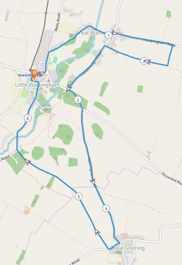
Walsingham – 6 mile
Meet at the the Mill car park off the high street in Little Walsingham. The 6 mile route will exit the car park on to Bridewell street we will turn left and continue to Guild street keeping to the left hand side in single file. We then cross Knight street going left and following the footpath until we turn right onto St Peters road. This road has no footpath so runners need to be aware of traffic. We then cross the bridge over the ford and continue to meet Scarborough road. Turning left we continue on Hindringham road for about ¾ until we arrive to a track that is a marked footpath on the right. We follow this track which is slightly uneven straight until we come to another right hand turn we take this continuing until we come to a farmhouse/yard that then rejoins Scarborough road.
We turn left and continue to the end of the road coming to a junction. Where there is footpath on this road ask the runners to use it. Meeting Snoring road we turn left and stay on this road all the way to Great Snoring. There is no footpath and runners should be encouraged to keep in small groups and run in single file when there is traffic to allow vehicles to pass safely. On entering Great Snoring take the first right on to Barsham road you will then come to a footpath on the right. This is a uneven track that continues all the way to the Fakenham road. The final section of track is deeply rutted so is best to run in the middle. Fakenham road is a busier road and runners should run towards the flow of traffic in single file. This then comes into Little Walsingham you will follow the High street to then return to the car park on the left.
6 Mile Route:
(click the image to download full map and turn by turn instructions)